On March 17, 2022 the U.S. Census released its 2016-2020 American Community Survey data. For the Connectivity Explorer, this was the first deployment to use the 2020-vintage geographic units that define the various Census geographies such as states, counties, places, school districts, and legislative districts. As of Release 0.45.0, scheduled for March 27, 2020, all Census data relates to 2020 geographic units.
The 2020 geographic units follow the usual Census conventions where the smallest units, Census blocks, are grouped into block groups; the block groups are then collected into tracts, and each tract is fully contained in a single county. Counties, of course, are fully contained in states. These areas are all defined by the Census.
Other areas, like places (cities and towns) or school districts, are politically defined, and show up as arbitrary regions that lie on top of this “backbone”.
The relationships among various of kinds of Localities appears in the accompanying figure. Except for the “Nation” level, all of these regions appear in the Connectivity Explorer.

When determining which Census blocks, block-groups, or tracts are included in, one of politically-defined regions such as a place or a school district, the application consults the underlying shapes on the map.
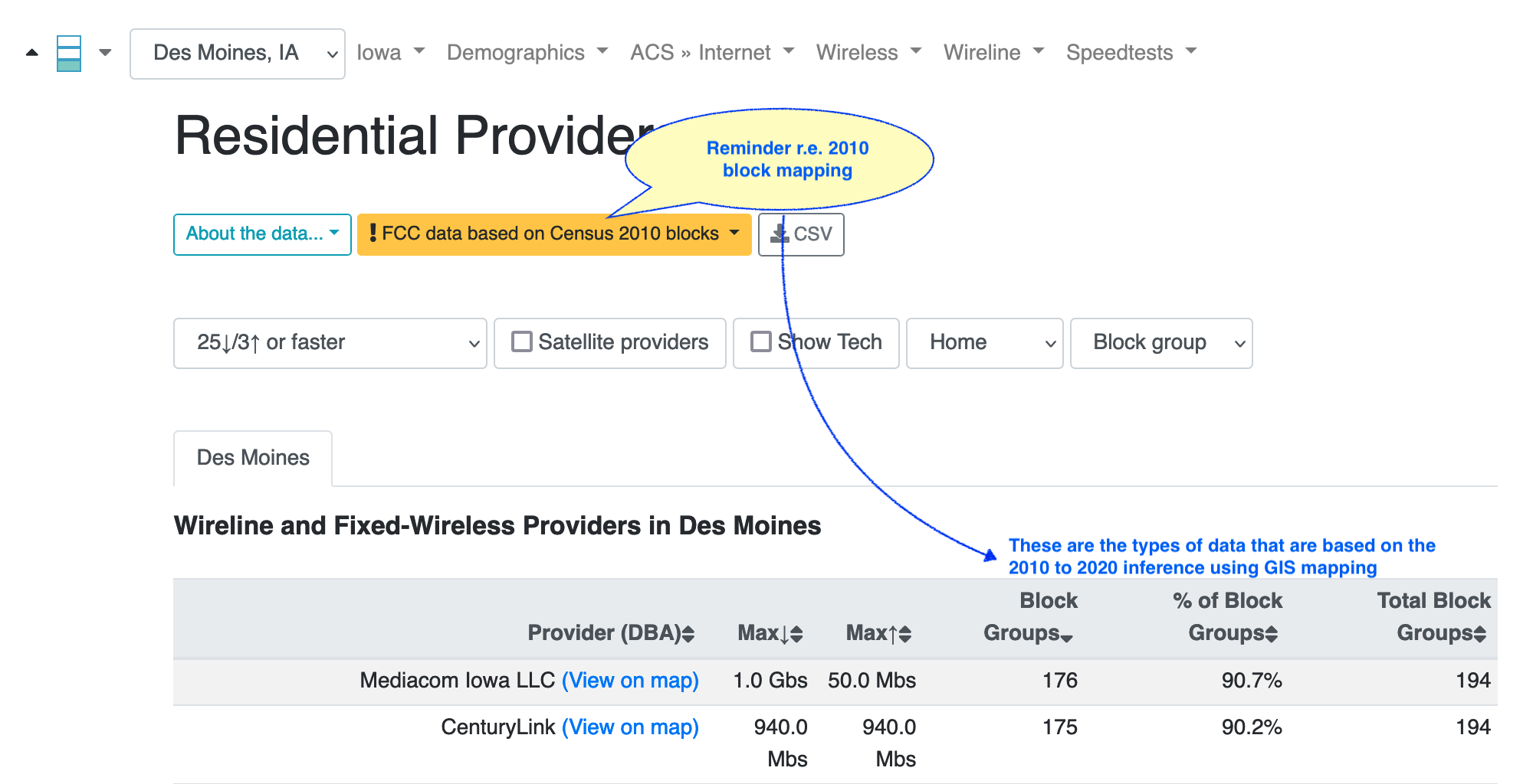
However, the current FCC 477 broadband deployment data is based on the 2010 Census block definitions. The Census encoding from a 2010 block to a 2020 block group, tract, or county no longer holds; a given 2010 block could overlap with more than one 2020 block group, tract, or county.
The FCC 477 broadband deployment data will change to use the 2020 Census block definitions in the release dated December 2021, but that release is not expected for several more months. Another year after that, the FCC 477 deployment will begin to transition away from Census blocks as their basic reporting unit and towards arbitrary regions for reporting deployment.
The historical FCC data, such as the auction data (CAF-II, RDOF) will continue to use the 2010 block definitions.
In response to these changes, the following strategy has been adopted for I3: treat the 2010 Census blocks like any other arbitrary region. Thus, when mapping 2010 Census blocks to 2020 block groups, 2020 tracts, or 2020 counties, the system will rely on map-based intersections. This is the same approach that is used to map Census blocks to other arbitrary regions like Census-defined places or school districts. The accuracy of this method, of course, depends on the accuracy of the GIS boundaries; its possible that minor inconsistencies can arise. Any statistics based on the number of blocks will be based on counts 2010 blocks, not 2020 blocks.
For example, consider the Wireline > Providers table, with data shown per block group. The application will consult all the 2010 blocks that geographically overlap with those block groups. This will result in the correct providers being show, and the code does its best to avoid double-counting blocks that now intersect with more than one block group in the area.
Here’s an annotated screen shot showing both a reminder about how the 2010 blocks are being handled, and the types of data affected:
However, it will be wisest to interpret the count of blocks as an estimate. The total number of blocks displayed will depend on the geographic shapes and their overlaps. It is no longer possible to map a single FCC record to a single Census block group.
The same techniques will be applied to the FCC CAF-II and RDOF auction data.
Given the mismatch between FCC and Census blocks, its no longer possible to map a single FCC record to a single Census block group. In prior releases, views that displayed block-level data used the surrounding block-group data as as a proxy for the data associated with the block. This feature has been removed; Census data is no longer attributed to block-level data. The impact for users will be seen in to the Wireline and Wireless Provider map views when drilling down to the block level. FCC block-level population estimates are still used in the various Auction, Rural/Urban, and Well-Served Block views. FCC block-level population estimates are still used in the various Auction, Rural/Urban, and Well-Served block views.
These changes foreshadow the changes that would have been needed once the FCC 477 data moves to arbitrary shapes instead of block-level reporting. So maybe we’re just arriving in the future a year or two sooner than planned! Now where did I put the keys to the Delorean? ![]()